
Current Projects
Time Machine
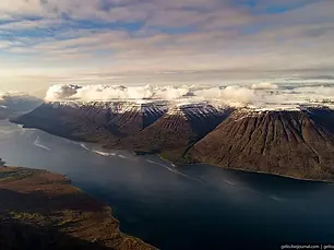
This project in collaboration with Prof Sophie Nowicki at the University at Buffalo, NY is focusing on the pre-industrial boundaries of the Greenland Ice Sheet (1350-1850 CE).
- Identifying set markers: trimlines, dating moraines, geomorphic features, archaeological sites and ship voyages
- Constructing a historical DEM
![Figure3_plus zoomin area_new [Converted].jpg](https://static.wixstatic.com/media/c70d8e_4d9c60929dc04330aa47a45973e04b96~mv2.jpg/v1/fill/w_306,h_229,al_c,q_80,usm_0.66_1.00_0.01,enc_avif,quality_auto/Figure3_plus%20zoomin%20area_new%20%5BConverted%5D.jpg)
Loss of Mountain Glaciers in Greenland
This is a collaborative project with Prof Jonathan Carrivick and his group at Leeds. Our investigation is looking into the quantity of mass loss in glaciers surrounding the Greenland Ice Sheet since the Little Ice Age (1850CE).
-Long Term glacial mass balance
-Importance of mountain glaciers
-Lake terminating vs. Marine

Low elevation Cirques
Low-elevation cirques located on/near the Lofoten Islands are unique as they are located near sea level. These cirques would require special precipitation and temperature conditions to form glaciers. Using the physical metrics of these glaciers, I am investigating any signature characteristics of these geomorphic cirques. Their conditions would occur during the transitional phase of an ice sheet.

Palaeoglacier reconstruction of Putorana, Russia
This is the first glacial reconstruction in the Putorana Nature Reserve. The mountain geomorphology has been mapped using Arctic DEM, following the use of ACME2 and GLaRE tools in GIS. Using these tools we can provide the morphometrics and glacial surfaces from the previous ice extent. Climatic conditions are also being estimated from glacial ELAs.
When's a glacier, a glacier?
This project is a spinoff of the ISMIP working group under Prof Sophie Nowicki (UB).
The aim of this project is to use a recently developed technique to analyse which glaciers should be classified as part of the Greenland Ice Sheet during its most recent advanced phase, and attempt to estimate when they should be quantified as a peripheral glacier.

University at Buffalo & Lamont-Doherty Earth Observatory
Under Jason Briner & Sophie Nowicki
Aims: multidisciplinary team integrating palaeo proxies and modelling to build an ice sheet model of the entire Greenland Ice Sheet
My role: providing a DEM of the Little Ice Age as a termination point for the project
Glaciers and Little Ice Age moraines in western Greenland. (Credit: Jason Briner)


Previous Projects
Cirque Equilibrium Line Altitudes as palaeoclimate indicators
https://doi.org/10.1016/j.palaeo.2022.111062 * Analysing palaeo cirque glacier equilibrium line altitudes as indicators of palaeoclimate across Scandinavia
* Mapped 4000 & evaluated palaeo cirques in ArcGIS in swaths across Norway & Sweden
* Applied the Automated Cirque Extraction tool in ArcGIS to extract physical cirque properties
* Completed advanced statistical analysis of cirque physical properties to connect to regional palaeo climates

60Ma Antarctica
34Ma dramatic cooling at the Eocene-Oligocene boundary
- We present data that mountain glaciers were present in the Transantarctic Mountains during the Late Palaeocene (60-56Ma)
-highlight the longevity of glaciation in Antarctica and suggests glaciers were present in a Greenhouse world of the early Cenozoic

Cool deltas: ice-contact deltas in Finland
doi: 10.1111/sed.12884
3 weeks of GPR, ERT & sedimentological profiles, Finland (Sept 2019) on the Salpausselka I & II
-Younger Dryas stadial of the Fennoscandian Ice Sheet
-deposition of subaqueous ice-contact fans

StateMap Project of Mahomet Quadrange
Worked with Dr. David Grimley
Published USGS Geomorphic Map
Perform geologic mapping of Quaternary deposits in 1:24,000 scale quadrangle
Data compilation and map computerization
Laboratory work of cores including descriptions, magnetic susceptibility
Field investigations and coring

Ecohydrology of a Tropical Montane Cloud Forest, San Isidro de Peñas Blancas, Costa Rica (NSF-REU @ Texas A & M)
This internship consisted of an analysis of a small watershed to more closely understand the water budget. My part of the project was to map the depth of bedrock (saprolitic tuff) in order to quantify the soil. A map estimate of the bedrock depth would give a volume of soil within the watershed and an estimate of the water holding capacity. Additional research was completed to characterize the properties of the soil within the watershed.
To complete this research we used the following methods:
Bucket Augering/Drilling – sampled over 100 holes
Particle Size Analysis via Hydrometer Method
ArcGIS & Surfer – constructed 3D map of soil morphology
Thermoluminescence Dating of Volcanic Tuff
Developed and completed research on soil hydrology with in the Howler Monkey watershed
Six weeks of field work in Costa Rica

Accuracy of GIS calculated ELAs vs measured mass balance
Cryosphere. https://doi.org/10.1017/jog.2021.100.
* Assessing the veracity of glacier equilibrium line altitudes calculated for satellite-derived glacier topography
* Completed a comparison of the accuracy of GIS-calculated ELAs vs. measured mass balance
* Executed a statistical analysis of the veracity of methodology in SPSS © of using satellite-derived ELAs
* Computed ELAs using ArcGIS toolbox
* Assessed accuracy of open-source data including GLIMS & WGMS aggregated by multiple users

Comparison between palaeo cirques and modern cirque ELA patterns
J. of Geomorphology. https://doi.org/10.1016/J.GEOMORPH.2019.106986
*Perform geomorphic mapping of modern Scandinavian cirque glaciers in ArcGIS
* Completed Pearson correlation and PCA to establish the relationship between cirque glaciers with modern climate
* Extracted ELAs using a newly developed ArcGIS toolset

Inception and sensitivity of the Fennoscandian Ice Sheet
Project: Using the Parallel Ice Sheet Model (PISM), a coupled numerical model of ice sheet/ice shelves to estimate the climatic conditions of the onset of the Fennoscandian Ice Sheet during the Eemian/Weischelian transition
-Executed sensitivity analysis of climatic parameters
-Python Application
-Collaborate and coordinate with advisors and consultation with Norwegian Geological Survey
-Geomorphic Mapping in the Romsdalen Fjord, Norway with Dr. Ola Fredin, Norwegian Geological Survey
-Cosmogenic and OSL sampling in Finndalen, Norway with Dr. David Egholm (Aarhus University )
Field work published in Andersen et al., 2018 (J. of Geophysical Research: Earth Surface) DOI:10.1029/2018JF004670
-Worked with Andy Aschwanden, Arctic Supercomputing Center, University of Alaska-Fairbanks

WIDER: Evidence-Based Learning Reform
Transform laboratory activities to active learning
Establish learning goals
Implement of laboratory homework
Purchase additional supplies including groundwater models and plate tectonics maps
Weekly surveys of students

Dune Geomorpholgy & Geochronology (NSF-REU @ UWisconsin-Platteville & UNebraska)
This internship consisted of an analysis of parabolic sand dunes of two previous high stands of Lake Michigan, Lake Nipissing and Lake Algoma, in Door County. Through this research, we are able to connect to wind patterns, lake levels and sediment supplies that occurred during the middle of the Holocene period from 5ka to 3.2ka.
To complete this research we used the following methods:
Ground Penetrating Radar
Particle Size Analysis
Optically stimulated luminescence dating using the SAR method lab work at the University of Nebraska, Lincoln
Developed and completed research on sand dunes on Lake Michigan
Research on climate and lake levels of Nipissing and Algoma Lakes
Four weeks of fieldwork in Door County, WI
Rawling III, J. E., & Hanson, P. R. (2014). Dune formation on late Holocene sandy bay barriers along Lake Michigan’s Door Peninsula: The importance of increased sediment supply following the Nipissing and Algoma high lake-level phases. Geological Society of America. https://doi.org/10.1130/2014.2508(05)
